The Nomads Outdoors Group Inc.
Powered by

** Nomads email addresses have changed to the format LeaderFredN@nomads.org.au, and may go into your Junk Folder as a result. See Some Recommendations about Nomads Emails to prevent that **
The Nomads is a social outdoors group for gay and gay-friendly men of all ages. It also welcomes those from the lesbian, bisexual and transgender communities, and anyone who shares its objectives of tolerance and acceptance.
 Check out the upcoming Nomads events
 If you don't receive a confirmation email, check your Spam folder!
  Check your currently active bookings (login required)
The Nomads would like to acknowledge the traditional custodians of the lands on which we meet for our events, and we pay our respects to Elders past and present.
Events
View all

Jul
15
Nomads Wednesday Cycling - 3rd Wed each month
10:30 – 16:00
Do you enjoy cycling, and are you sometimes free on Wednesdays? You're welcome to join the Nomads Wednesday cyclists.
** See Archive - Wednesday Bike Rides for the upcoming Wednesday's cycling details (posted on the prior Monday night). **
GRADE | LENGTH | TYPE: Rides are of varying length and difficulty, mostly in metro Melbourne, but sometimes in Regional Victoria. The typical distance is between 30 and 50 km, though there are usually options to either extend or shorten the ride.
ACTIVITY DESCRIPTION: Time off on Wednesdays? Join a small group of Nomads and friends for a leisurely cycle on trails around metro Melbourne, and occasionally into Regional Victoria, usually on the third Wednesday of the month. Emphasis is on the social aspect, not on breaking world speed records! All rides are designed to either start in central Melbourne, or to start and finish close to train stations. The rides usually start at around 10:30am to avoid needing to travel with bikes on trains in peak hour. We often meet in, or near, a cafe so you can have a coffee prior to starting the ride if you wish. We generally have lunch in a cafe or pub along the way, though occasionally you will need to bring a picnic lunch if there are no suitable options available - in that case the ride description will clearly indicate the need to BYO lunch.
The upcoming ride details are emailed to everybody on the Wednesday Cyclists Mailing List, usually on the prior Monday evening, by which time the weather forecast for Wednesday is fairly reliable. That way, a ride can be chosen to suit the forecast, for example to keep the wind behind us as much as possible, and to ensure there are bailout train station options if there’s a likelihood of rain.
(Tip: the details are also added at the start of the Archive - Wednesday Bike Rides document).
If you have any additional enquiries or requests, email Chris Stewart on LeaderChrisS@nomads.org.au. If you're not sure whether your bike fitness level will match, contact Chris to plan your first foray.
BOOKING:
MAILING LIST: To join the mailing list so that you receive an email (usually on Monday evening) about the upcoming Wednesday ride, click on Get Tickets in this event. (Afterwards click the "+" to set the number of tickets to 1, click Checkout and follow the prompts to provide your contact details). You only need to do this once. If you decide in future that you don't wish to receive the weekly emails, just email LeaderChrisS@nomads.org.au to be taken off the mailing list.
RIDING: When you plan to ride, please put your name in a free cell of the Wednesday Attendees spreadsheet on the day prior (be sure to click out of the cell afterwards, so that your name gets automatically saved). If a blank cell has a coloured box around it, somebody else is currently entering their name in that cell, so select the next cell instead. Your first name plus the first letter of your surname will suffice. If having difficulty, just reply to the email or email LeaderChrisS@nomads.org.au.
COST: Free. Note that for most Nomads activities, visitors need to pay a small fee, but as an introductory offer that fee is waived for the monthly social nights and the regular Wednesday and Friday bike rides - a way for you to meet some club members and find out a little more about the club. After attending 5 or more rides, you will be asked to become a member though.
FURTHER INFORMATION: Please see Cycling Tips for some things to consider prior to hopping on your bike.
LEADER: Chris S. | Email LeaderChrisS@nomads.org.au if you have any questions.
Members can access leader contact details under Members | Leader Contacts when logged in to the website.
HOME BACK TO LIST OF EVENTS MEMBERSHIPS
Jul
19
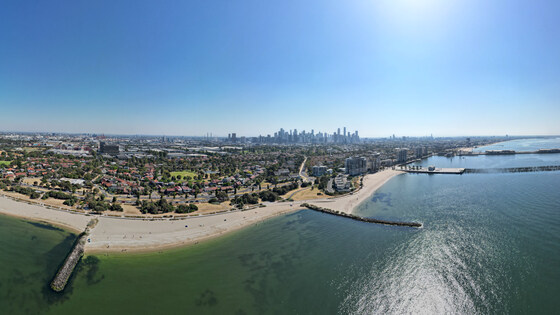
Station Pier to Newport Station via the Westgate Punt
Beacon Cove/Light Rail Stop
10:40 – 16:00
NOTE: Due to the Run Melbourne Event in the CBD & Docklands - changes to Trams until Lunchtime
Check https://transport.vic.gov.au for Details.
Enjoy a scenic walk overlooking Port Phillip Bay and the Lower reaches of the Yarra River, crossing the Yarra River on the Westgate Punt.
GRADE | LENGTH | TYPE: Grade 3 Medium, 10 km point-to-point walk on paved or compacted dirt paths (graded according to the AWTGS: Australian Walking Tracks Grading System).
ACTIVITY DESCRIPTION: From the Beacon Cove Terminus of the #109 Tram, the walk will follow the Beacon Cove Promenade Trail past one of Melbourne's earliest urban renewal projects plus Station Pier and Princess Pier. Passing through the Maritime Cove Parkland, the walk will make the return trip along the Webb Trail to Sandridge Lookout. Next the walk will head to Westgate Park which will be the lunch spot in designated facilities. Then a walk through Westgate Park to the Punt pier (near the Westgate Bridge) to cross over the Yarra River. On the western side the walk will continue on off-road paths past the historic sewerage pumping station and the Newport Power Station. We'll exit to take North Road to Newport Station, where you can board a train to return towards the CBD.
BOOKING: By Friday 17th July. To register click on Get Tickets.
Unsure if you've already booked? Click View my bookings.
MEETING TIME | LOCATION: 10:40am at Beacon Cove Terminus, Port Melbourne. If you'd like a coffee, you should arrive at the terminus on the 10:10am tram. See Public Transport below.
MAP REFERENCE: Google map: maps.app.goo.gl/9cnPPGVWN26nBJ968.
PUBLIC TRANSPORT:
For the 2nd half of 2026, fares are at 1/2 price - Myki money weekend daily cap is $4.00 Full Fare and $2 Concession Rate + Seniors FREE
WITH COFFEE: Take the #109 Tram via Collins Street and Southern Cross Station that arrives at 10:10am
NO COFFEE: Take the #109 Tram via Collins Street and Southern Cross Station that arrives at 10:40am
RETURN: Newport Station is on the Werribee and Williamstown lines, with trains at least once every 10 minutes.
FOOD: Lunch break will be at Westgate Park, BYO eats and beverages - there are NO food outlets in the vicinity.
COST: $5 for the Westgate Punt | NO CASH, only EFT Payments.
APPAREL | FOOTWEAR: Comfortable attire including footwear that's suitable for the weather forecast.
LEADER: Garry Oliver | Email LeaderGarryO@nomads.org.au if you have any questions.
Members can access leader contact details under Members | Leader Contacts when logged in to the website.
Image: Bob Tan
HOME BACK TO LIST OF EVENTS MEMBERSHIPS
Jul
26
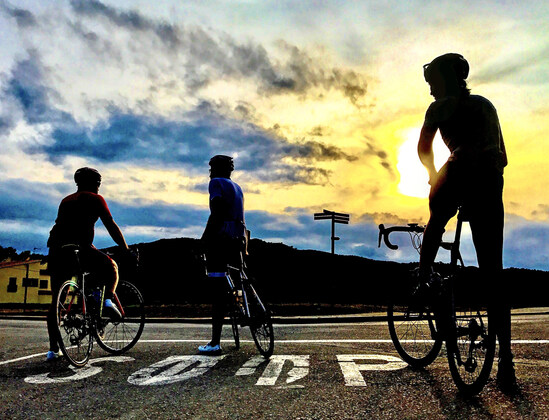
Waynieo and Bry Bry's Sunday Morning Jaunt
07:50 – 11:30
A warm invitation to join Wayne and Bryan on their (pretty) regular fortnightly Sunday morning ride from Kooyong to Hampton (and sometimes Mordialloc).
GRADE | LENGTH | TYPE: Ride distance is approx 34 km from Kooyong to Hampton station. 48 km if you ride to Mordialloc. You add on your ride distance to home - or you catch the train back from Hampton or Mordy.
ACTIVITY DESCRIPTION: This is a 'working-on-our-riding-fitness' ride. We do it every second Sunday morning - more or less. We begin at Kooyong Tennis Stadium at 7.25am and take Gardiners Creek Trail into the city. You are free to join at several points along the way. Kooyong (7.25am); Birrarung Marr Walk (7.50am); Port Melbourne Beach (8.40am).
We ride the same route each time. We pick up Gardiners Creek at Glenferrie Road and ride to Birrarung Marr Walk, then through Southbank onto Lorimer Street - Westgate Park to Port Melbourne, Beaconsfield Parade to St Kilda and Beach Road to Hampton. We ride on trails, on quiet roads and a choice of bike path or road from Port Melbourne to Hampton. For the Beach Road section, riders choose whichever option (bike path or road) they are most comfortable with. At Hampton we stop for coffee - right next to Hampton station. We don't stop much on the ride apart from road crossings at lights and a toilet stop in Westgate Park. Oh Yeah :) We ride at a steady pace. We surge a bit down Lorimer Street. We take it carefully on Beach Road or bike paths where there are other forms of traffic (runners/ walkers/cyclists/cars etc). Coffee in Hampton is for about 30 mins, then we move on. Post-coffee choices are to ride onto Mordy, head home on your bike or catch the train. It's a morning ride and we aim to be back home by 11.00 - 11.30am. The rest of the day is yours and you're feeling great, having done a beautiful Sunday morning Melbourne ride.
BOOKING: We communicate via SMS if required, such as - "it's raining we're not going" or "good weather - we're on!". This generally happens on the morning of the ride. Early. Around 6.30am. Check your messages before you leave home. If you are keen to join this ride email Bryan and we can exchange numbers for communication purposes. Proposed ride dates at this stage are 12 & 26 July; 23 & 30 August; 13 September.
MEETING TIME | LOCATION: Gardiner's Creek( next to Kooyong Lawn Tennis Club) at 7.25am. Birrarung Marr Walk at 7.50am. Port Melbourne Roundabout at 8.40am. All meeting times are sharp!
MAP REFERENCE: Google map of the route: Kooyong Tennis Centre - Fed Square - Westgate Park - Hampton - Mordialloc.
PUBLIC TRANSPORT: The ride interlinks with trains at Flinders Street, Hampton and Mordialloc stations.
FOOD: Water, rain gear, tube/pump, phone, helmet, glasses, $ for coffee/muffin
APPAREL | FOOTWEAR: Your riding gear. You know the drill.
LEADER: Bryan S. | Email Bryan on LeaderBryanS@nomads.org.au if you have any questions.
Members can access leader contact details under Members | Leader Contacts when logged in to the website.
HOME BACK TO LIST OF EVENTS MEMBERSHIPS